
Humans have used robotic surrogates to explore Mars’s geology since 1997, when the Sojourner rover crawled the length of a football field on the red planet’s surface. But while the robots we’ve sent to Mars have grown more sophisticated over time, one question in particular lingers: would rover-collected and human-collected data from the same rocks lead us to the same conclusions?
Remote Investigations of the Red Planet
The Mars rovers have advanced our understanding of Mars’s current geology and past history, including providing evidence that our neighboring planet once had persistent liquid water on its surface. But while the Mars rovers have extended geologists’ reach by millions of miles, robotic rovers and human geologists are not the same: a rover’s resources are exceedingly scarce, requiring teams of scientists on Earth to plan its observations carefully, while a human team can operate more flexibly and make decisions on the fly.
It’s possible that the inherent limitations of rover data affect the conclusions that scientists on Earth draw from those data. Since we can’t (yet) send human geologists to Mars to compare their observations to those made by the Mars rovers, scientists got creative and instead used human rovers on Earth to learn more about this issue.
Thinking Like a Rover
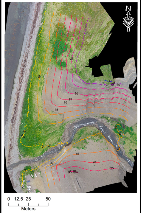
Aerial view of the field site in Iceland, acquired with a drone to mimic orbital data. [Yingst et al. 2022]
Yingst and coauthors asked a human team and a “rover” team to investigate the rock outcropping using commercial instruments with similar resolution to those on the Mars rover. The human team used standard field techniques to study the outcropping while the rover team studied the rocks remotely, directing just two team members to act as the “rover” and take measurements based on the instructions of team members who were not at the field site. Both teams planned their investigations using aerial photographs of the region, similar to how rover missions use images from orbiting spacecraft for reconnaissance.
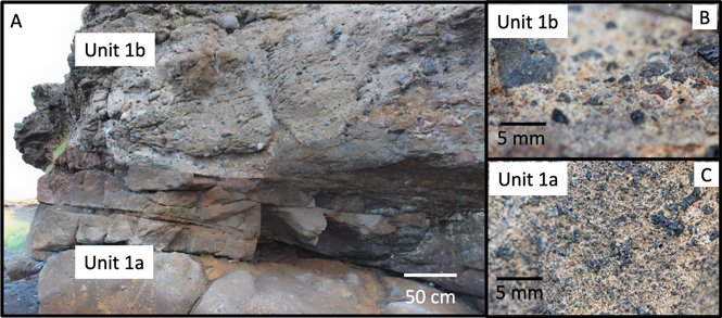
Images collected by the rover team. Click to enlarge. [Yingst et al. 2022]
Notes for the Future
Yingst and collaborators found that the rover team was typically able to determine if materials were volcanic or sedimentary, but the human team made more accurate and more detailed assessments, and they were able to place the materials in context. This may have been because the human team was able to trace rock layers horizontally and make observations from various distances, which allowed them to determine if certain features were continuous between regions as well as determine the scale of the features.
The authors noted that the ability to make observations from different distances or angles was crucial to the traditional field team’s success. This finding might prompt future Mars rover investigations to allocate more time to collecting images at certain resolutions, if those images might hold the key to correct identifications.
Citation
“Using Rover-analogous Methodology to Discriminate Between Volcanic and Sedimentary Origins in Successions Dominated by Igneous Composition,” R. Aileen Yingst et al 2022 Planet. Sci. J. 3 240. doi:10.3847/PSJ/ac8429