
Three and a half billion years ago, a mile-wide rock haphazardly slammed into the south pole of the Moon. About three years from today, a human-made ship carrying the Artemis III crew will land much more gingerly in the same spot and survey the damage. To make the most of their limited time there, scientists are mapping out where they should go and what they might see.
Back to the Moon
While most exploration within astronomy centers on observing places beyond the physical reaches of humanity, there’s an undeniable romanticism behind our vision to visit our nearest neighbors in person. In the last 50 years, though, we’ve been collectively reclusive; although our robotic emissaries have been busy, no human has left the confines of Earth’s gravitational dominance since before the first personal computers hit shelves.
That’s likely about to change soon, however. While the political winds that govern such endeavors could shift, the previous two presidential administrations have stood by the Artemis program, which aims to send astronauts around the Moon in 2023, and to land on the lunar south pole in late 2025 the earliest.
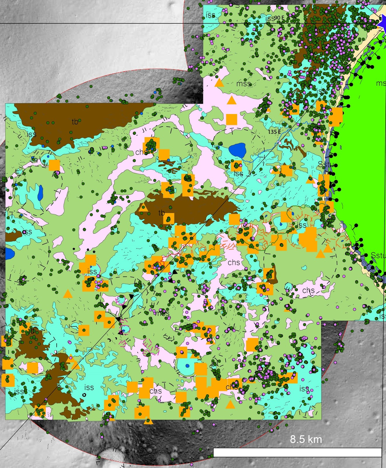
A geologic map of the area surrounding the likely Artemis III landing site. Individual boulders, rocky craters, and rock exposures mapped in this study are included as dots. Click for high-resolution version. [Adapted from Boazman et al. 2023 and Bernhardt et al. 2022]
Remote Cartography
These future moonwalkers will need a careful plan to maximize the scientific return of their precious few days on the surface. Recently, a team led by Sarah Boazman (European Space Research and Technology Centre) used data from the Lunar Reconnaissance Orbiter to get started on this necessary preparation. Published in the Planetary Science Journal, Boazman and collaborators created a new map of potential geologic sampling sites near the likely Artemis III landing site. Their survey specifically flags isolated boulders, rocky craters, and rock exposures that could be reached by astronauts on foot, adding context to previous geologic maps of the polar regions.
After a thorough analysis (they team flagged over 86,000 individual boulders alone), Boazman and collaborators conclude that many of the boulders near the probable Artemis III landing site are associated with the impact that formed Shackleton crater, the 21-kilometer depression that hosts several permanently shadowed regions packed with ices.

Isolated boulders flagged in the study, overlaid on a lower-resolution image of the same region. [Adapted from Boazman et al. 2023]
Although the Artemis III crew will be the only humans physically on the Moon once they land, they’ll carry with them the curiosity of thousands of planetary scientists back here on Earth. It is a thrilling time when astronomers can make maps of other worlds in preparation for a journey there, and hopefully the wait won’t be long for an astronaut to size up one of the targets on this map in person.
Citation
“The Distribution and Accessibility of Geologic Targets near the Lunar South Pole and Candidate Artemis Landing Sites,” Sarah. J. Boazman et al 2023 Planet Sci. J. 3 275. doi:10.3847/PSJ/aca590