
Was Mars once partially covered in ancient seas? A recent study has found new evidence to support the Mars ocean hypothesis.
Signs Point to Seas
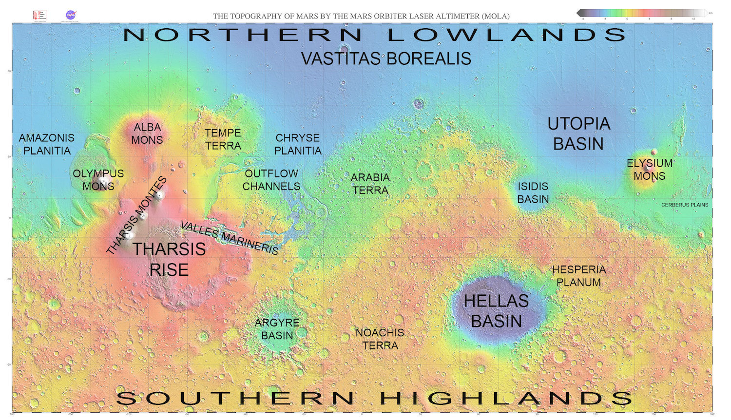
A map of Mars’s topography created by the Mars Orbiter Laser Altimeter shows two distinct southern and northern hemispheres. Click to enlarge. [NASA/JPL/GSFC/MOLA. Map by Emily Lakdawalla]
The discovery of the Martian dichotomy — a ~30 km difference in height between the lower, smooth northern hemisphere and higher, heavily cratered southern hemisphere — was an early indication that the northern hemisphere may once have been underwater.
Long, unbroken features identified as potential ancient shorelines were spotted on Mars as early as the 1970s by the Viking orbiters, further supporting a picture of vast past oceans.
And dozens of further clues have piled up: signs of stream channels and river deltas, indications of past rainfall, hints of historical tsunamis from asteroid impacts, atmospheric signatures that point to a past abundant water supply — the list goes on.
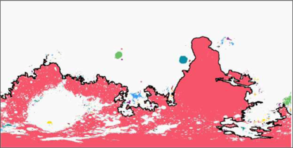
In this proposed map of an ancient ocean on Mars, underwater regions are indicated in white, and the above- and below-water regions are separated by a proposed sea level (solid line). [Saberi 2020]
A Liquid Controversy
Yet the Mars ocean hypothesis remains highly controversial.
The Martian dichotomy could have been caused by a megaimpact, or by thinning of the northern-hemisphere crust. Observed “stream channels” might instead have been created by wind erosion. And those possible ancient shorelines? They’re not actually level — they vary in elevation by a couple of kilometers along their length, which is not something a sea level should do.
On this other hand, the shorelines might have started level and been deformed more recently. Clearly, more evidence is needed in the debate over Martian oceans — and now we’ve got it, in a new study by Abbas Ali Saberi (University of Tehran, Iran; University of Cologne, Germany).
Moving the Level
Saberi argues that a giant ancient ocean covering part of Mars should have left distinct signatures in the elevation profile of the planet — signatures that we can identify in comparison with Earth’s topography. Saberi combines detailed maps of Mars’s surface altitudes from the Mars Orbiter Laser Altimeter with statistical modeling called percolation theory to search for these signatures.
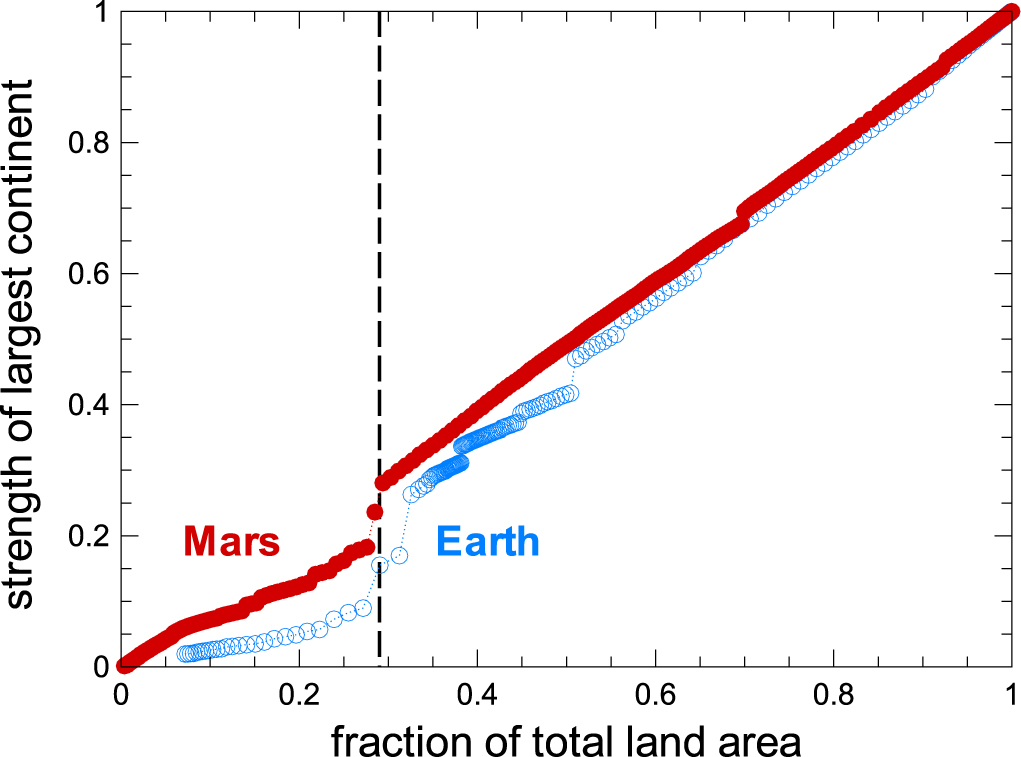
As sea level height is changed in the authors’ models, the relative surface area of the largest island to the total area of Mars (red) and Earth (blue) shows a jump for both planets that corresponds to Earth’s current sea level and a sea level height of 1,400 m on Mars. [Saberi 2020]
When Saberi applies this model to Mars’s topography, a phase transition occurs in the exact same way, showing a distinct change at a sea level of 1,400 meters (measured relative to Mars’s equatorial radius of 3,396.2 km) and indicating that Mars may indeed have had an ancient sea of this height. This elevation also displays the longest contour lines in Mars’s topography, further strengthening the argument that it corresponds to an ancient sea level.
So is the question of past oceans on Mars settled? Far from it! But we can expect clues to continue to roll in with upcoming missions to the Red Planet, like the Mars 2020 mission launching later this month.
Citation
“Evidence for an Ancient Sea Level on Mars,” Abbas Ali Saberi 2020 ApJL 896 L25. doi:10.3847/2041-8213/ab982d
4 Comments
Pingback: Pruebas de un antiguo océano marciano – Observatori Astronòmic
Pingback: توزیع دوقلهای از برآمدگیها و فرورفتگیها الگو شباهت مریخ با زمینِ هستند: پژوهش های ویژه استاد دانشگاه تهران -
Pingback: Mars’ missing water might still be in its crust | EarthSky.org - My Space
Pingback: Marsâ missing water might still be in its crust – Menopausal Mother Nature